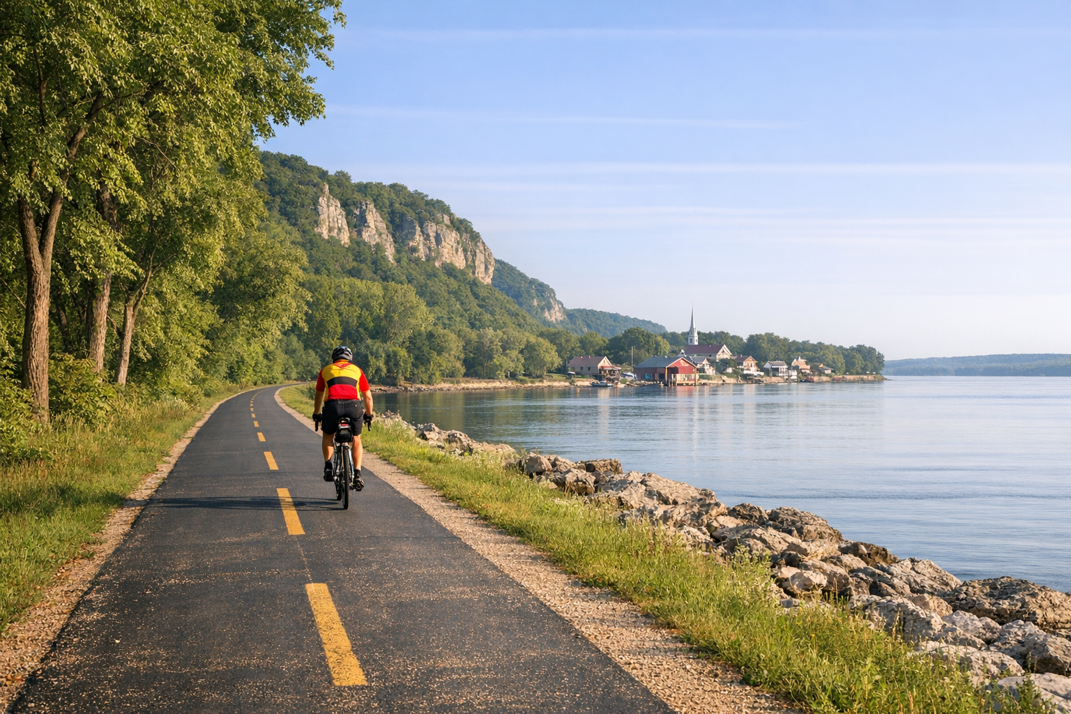
Stretching 62 miles along the Mississippi River in Illinois, the Great River Trail offers a scenic, mostly flat route perfect for cyclists of all skill levels. Starting in Rock Island and ending in Savanna, this path connects 11 riverfront communities and is part of major national trail networks like the Mississippi River Trail and American Discovery Trail. Riders can enjoy diverse landscapes, including urban riverfronts, quiet rural roads, and natural areas like the Mississippi Palisades State Park.
Key Highlights:
- Trail Length: 62 miles, with a 1% average grade.
- Terrain: Mostly paved asphalt; northern sections include rural roads and some gravel.
- Scenery: Mississippi River views, wildlife habitats, historic sites, and river bluffs.
- Top Stops: Albany Indian Mounds, De Immigrant Windmill, Thomson-Fulton Sand Prairie.
- Services: Food, lodging, and bike repair available in connected communities.
Whether you're planning a short ride or tackling the full trail, this guide covers everything you need to know for a smooth and enjoyable cycling adventure.
@figure  {Great River Trail Quick Facts: 62-Mile Route Statistics and Key Information}
Route Overview: Rock Island to Savanna
Trail Segments and Terrain
The trail stretches 62 miles, starting at Sunset Park and Marina in Rock Island and ending at Broderick Drive in Savanna. Along the way, it weaves through 11 riverfront communities, offering a mix of urban and rural landscapes.
Key segments include:
- Rock Island to Sylvan Gateway Park (5.5 miles): This section begins at Sunset Marina, offering scenic river views.
- Moline via Ben Butterworth Parkway (4.2 miles): A smooth ride through Moline’s vibrant riverfront.
- East Moline to Rapids City (8.4 miles): Passes through Hampton and Illiniwek Forest Preserve.
- Port Byron to Cordova (7.4 miles): A quieter stretch with small-town charm.
- Cordova to the County Line (8.3 miles): Stunning riverfront vistas dominate this segment.
- Albany, Fulton, and Thomson to Savanna (30 miles): The longest stretch, featuring a mix of rural roads and natural beauty.
The trail surface is mostly asphalt and concrete, though some areas include sidewalks, shared streets, and road shoulders. In the northern half, roughly 50–65% of the route follows rural roads, with a challenging 2-mile section on Uther Road featuring unstable gravel. The southern sections near Rock Island and Moline may have occasional cracks or uneven surfaces.
The route is mostly flat, but there are some notable challenges. A steep hill awaits just outside Fulton, and the bluffs near Savanna include grades as steep as 12%. Elevation varies between 550 and 800 feet. Much of the southern trail runs along river levees, offering elevated views but carrying a risk of flooding during high water.
These diverse segments provide a dynamic cycling experience, setting the stage for the scenic highlights described below.
Scenic Views Along the Trail
The trail offers a changing tapestry of sights, blending urban landmarks with natural beauty. In the southern Quad Cities area, riders will pass notable spots like Arsenal Island, home to the Rock Island Arsenal, the I-74 Bridge pedestrian path, and Schwiebert Riverfront Park. The Hampton section features views of Campbell's Island, a historic War of 1812 battle site, and the iconic John Deere manufacturing plant.
As the trail moves north, the scenery becomes even more diverse. Near Albany, you'll find the Albany Indian Mounds State Historic Site, home to ancient burial mounds from the Hopewell culture. In Fulton, highlights include "De Immigrant", an authentic Dutch windmill brought over from the Netherlands, and Heritage Canyon, a recreated 19th-century village. In Thomson, the trail passes through the Thomson-Fulton Sand Prairie and the Ingersoll Wetlands Learning Center. Near the northern terminus in Savanna, the Mississippi Palisades State Park offers towering bluffs and a chance for adventurous cyclists to ascend for breathtaking river views.
The trail closely follows the Great River Road National Scenic Byway (Illinois Highways 92 and 84), ensuring the Mississippi River remains a constant companion. Wildlife sightings are frequent, with bald eagles, great blue herons, deer, turkeys, and foxes often making appearances.
Key Stops and Attractions
Top Attractions for Cyclists
Stretching 62 miles, this trail is packed with over 80 attractions, making it a dream for cyclists who love to explore. One of the first standout stops is Sylvan Island in Moline. Once an industrial site, this area has been transformed into a recreational haven. Its 1-mile loop of crushed limestone paths winds through scenic spots filled with lily pads and waterfowl, offering a peaceful start to the ride. Another gem in Moline is Ben Butterworth Parkway, a 2.2-mile stretch featuring picnic areas, playgrounds, fishing spots, and even a marina - perfect for a mid-ride breather.
For those fascinated by history, the Albany Mounds State Historic Site is a must-see. These ancient burial mounds, remnants of the Hopewell culture, offer a glimpse into the lives of the region’s earliest inhabitants. Further along in Fulton, you’ll find De Immigrant, a Dutch windmill that was pre-assembled in the Netherlands and now serves as a charming trail landmark. Nearby, the Thomson-Fulton Sand Prairie offers a surprising sight - sand dunes and prickly pear cacti, all thanks to glacial deposits.
At the trail’s northern end, cyclists are rewarded with the breathtaking Mississippi Palisades State Park in Savanna. Towering bluffs provide stunning views of the Mississippi River. As the NRT Web App describes, “Spectacular views await the hearty in the City of Savanna, where as a side challenge, you can try a climb to the top of the towering bluffs of Mississippi Palisades State Park”. Other highlights include Lock and Dam No. 15 near Rock Island, offering a peek at the Mississippi’s industrial workings, and the Upper Mississippi River National Wildlife and Fish Refuge at Spring Lake, where you can spot Blue Herons, turtles, and other wildlife.
With so many attractions along the way, cyclists can easily find spots to rest, refuel, and enjoy the scenery.
Local Services and Businesses
The trail weaves through 11 communities, each offering plenty of options for dining, lodging, and shopping. In Rock Island, The District is a vibrant hub for food and shopping. Cyclists in Moline can stock up on gear at Active Endeavors or grab a meal at The Edge Eatery & Drinkatorium. Rapids City is another favorite stop, especially for its “Taco Rides,” a local tradition.
For those tackling the full trail, Rustic River Cabins in Savanna provides a cozy overnight stay, while the Inn at 1883 is another option near the northern end. Many trailheads located in municipal parks make it easy to access nearby cafes and businesses. Plus, the Channel Cat Water Taxi at Ben Butterworth Park is a unique feature - it’s equipped with bike racks, allowing riders to cross the river and explore the Iowa side of the Quad Cities.
Whether you’re looking for a quick snack, a comfortable place to sleep, or a way to extend your adventure, the local communities have you covered.
The Great River Bike Trail near Savannah & Thomson Illinois
sbb-itb-396215c
Amenities and Services Along the Trail
Cyclists embarking on the trail will find plenty of amenities to make their journey more comfortable and enjoyable.
Rest Areas and Water Stops
The trail is dotted with convenient spots to rest and rehydrate. At the Albany Indian Mounds State Historic Site, you'll find a shelter, water fountain, and pit toilets to take a break from your ride. In Port Byron, the area near the "Will B. Rolling" statue - a whimsical statue of a cyclist on a vintage bike - features a public restroom and water fountain. Further along in Cordova, riverfront parks provide access to water. Keep in mind that some water fountains are seasonal, so it’s a good idea to bring extra water during early spring or late fall.
Parking and Trail Access Points
Accessing the trail is simple, thanks to numerous trailheads along the 60-mile route. Starting at the southern end, Sunset Park and Marina in Rock Island offers 250 acres of wooded parkland, complete with parking, restrooms, and picnic areas. If you're looking for downtown access, Schwiebert Riverfront Park in Rock Island provides parking and modern facilities. Heading north, trailheads like Ben Butterworth Parkway in Moline, Empire Park in East Moline, and Illiniwek Forest Preserve in Hampton all offer parking and direct access to the trail. Additional entry points include Shuler's Shady Grove Park in Rapids City and the riverfront park in Port Byron. Best of all, there are no fees to access the trail at any of these locations.
Bike Repair and Maintenance Services
For cyclists needing repairs or rentals, Arnold's Bikes in Thomson is a vital stop on the northern half of the trail. They provide both maintenance services and bike rentals to keep you rolling. In the southern section near Rock Island and Moline, urban commercial districts host several bike shops for additional support. However, the stretch between Savanna and Fulton offers limited mechanical help. For these more remote areas, it’s smart to carry a basic repair kit with spare tubes and tools, especially when navigating the isolated prairie sections near Thomson.
These amenities and services ensure that cyclists can enjoy the trail with confidence, whether they’re tackling just a short section or the entire route.
Preparation and Safety Tips for Long-Distance Riders
If you're gearing up for the 60-mile Great River Trail, preparation is everything. While the trail winds through 11 communities with restaurants and stores, there's a 30-mile stretch between the Rock Island County line and Savanna where services might be sparse. Make sure to bring plenty of water, snacks, and an 8-liter hydration pack to carry all your essentials.
What to Pack for the Ride
Staying prepared for the weather is crucial on this trail. During the summer, the sun can be relentless, and shade is limited. Packing bandanas or cooling sleeves for sun protection is a smart move. Cyclist Nichole Jones shared her experience:
"I could feel my arms frying in the sun and had to take turns tying my bandana around each one to minimize the damage".
A lightweight rain jacket is also a must for those sudden summer showers. For navigation, equip yourself with a smartphone loaded with GPS apps or a bike computer with interactive maps like those from TrailLink or AllTrails. Don’t forget a basic repair kit stocked with spare tubes and tools. And if your ride might stretch into the evening, pack a flashlight or headlamp and wear reflective clothing to stay visible.
With the right gear in hand, you’ll be ready to focus on safety and enjoy the ride.
Safety and Trail Etiquette
The Great River Trail passes through floodplain areas, so it's wise to check water levels before heading out. Flooding or standing water can create hazards along some sections. Keep in mind that the region saw 118 crashes between 2018 and 2022. To stay safe, always signal when passing hikers, walkers, or those with leashed dogs. And if you spot box turtles crossing the trail, lend a hand by helping them continue in the direction they’re heading - it’s a simple way to protect the local wildlife.
For solo riders, let someone know your route and estimated arrival time. A little planning can go a long way in ensuring a safe and enjoyable journey.
Best Times of Year to Ride
The trail is most popular from late spring to early summer, especially between Memorial Day and the Fourth of July. Just be ready for high temperatures and the possibility of thunderstorms. Fall is another fantastic time to ride, offering cooler weather and breathtaking views of the changing leaves along the river valley. Thanks to its gentle 1% grade, the trail is accessible year-round and even welcomes winter activities like cross-country skiing and snowshoeing.
Plan Your Great River Trail Adventure
Stretching about 62 miles along the Mississippi River, the Great River Trail offers a flat, picturesque ride that connects charming riverfront communities while highlighting both historical and natural landmarks. With an easy 1% average grade and a mix of scenery - ranging from bustling urban waterfronts to dramatic bluffs - the trail welcomes riders of all experience levels.
For a seamless adventure, QC.LocalDayTrips.com is your go-to resource. The site features interactive maps with downloadable GPS data, real-time updates on trail conditions (including flood alerts), and detailed information about trailheads. You can explore specific trail segments, find nearby services, and even log your ride to collect fun badges.
QC.LocalDayTrips.com also equips you with practical tools for both short outings and extended trips. Use it to plan trailhead access, check current weather, or confirm trail conditions with local managers. You can even download Points of Interest files to pinpoint restrooms, water fountains, and dining options along your journey.
The Great River Trail isn’t just about the ride - it’s a chance to dive into the beauty of nature and the charm of small-town America. With its breathtaking river views and a 4.6 out of 5-star rating from riders, it’s no wonder this trail is a favorite. Start planning your trip today and experience it for yourself!
FAQs
The best times to explore the Great River Trail are during spring (April–May) and fall (September–October). In spring, you’ll enjoy mild weather, blooming landscapes, and lower humidity - perfect for long rides without feeling overheated. Fall, meanwhile, brings crisp air, breathtaking autumn colors, and quieter paths, creating a serene and picturesque cycling experience.
September stands out as a favorite month since it aligns with "Drive the Great River Road Month." During this time, the Mississippi River region bursts with vibrant fall hues, lively local festivals, and bustling farmers' markets. Whether you’re drawn to the fresh energy of spring or the warm, scenic charm of fall, both seasons offer an unforgettable ride on the trail.
The Great River Trail offers a mostly flat route, perfect for long-distance cyclists who enjoy a smooth and steady ride. Around the Quad Cities, you'll find paved paths and low-traffic roads, with only slight elevation changes to keep things interesting. Thanks to its easy rating, the trail is suitable for riders of all experience levels.
There are a few short gravel stretches along the way, such as the final quarter-mile leading into Hernando De Soto River Park, but these are brief and easy to navigate. The trail primarily follows the river levee and existing roadways, featuring gentle rolling terrain instead of steep climbs. Any difficulty you're likely to face will come from the trail's length or the occasional unpaved section, rather than challenging inclines.
For a successful long-distance ride on the Great River Trail, it’s important to pack smart to stay hydrated, energized, and ready for whatever the trail throws your way. Start with plenty of water - at least 2–3 liters - since water refill stations are few and far between. Pair that with some high-energy snacks like trail mix or energy bars to keep your stamina up during the ride.
Don’t forget to protect yourself from the sun. Pack sunscreen, sunglasses, and a lightweight hat to shield yourself from the heat, as summer temperatures can climb into the mid-90s with high humidity. For clothing, go with breathable, moisture-wicking fabrics to stay comfortable, and toss in a light rain jacket for those unpredictable weather moments.
Navigation is another key consideration. Since trail signage can be sparse, bring a printed map or have a reliable app ready to guide you. And, of course, be prepared for bike maintenance. A basic repair kit with essentials like a spare tube, tire levers, a mini pump, and a multi-tool will help you tackle minor fixes without cutting your ride short. With these essentials, you’ll be set to enjoy the trail’s 60-plus miles of stunning scenery.